Cassowary Coast Alliance - for the future
Follow us
  • CCA latest news
  • Conservation History
  • Traditional Owners
  • About CCA
  • Campaigns
    • Port Hinchinbrook
    • Ella Bay
    • Boat Bay/Clump Point
  • Photo Gallery
  • Contact

The New Bulletin #1 December 2018

9/12/2018

0 Comments

 
Picture
The New Bulletin is a collation of articles  provided by individuals or groups who share  the ethos of the Cassowary Coast Alliance.

The Cassowary Coast Alliance (CCA) is a collaborative hub for entities and individuals who 
are actively seeking good quality and long term public interest outcomes for the World Heritage listed Cassowary Coast in Far North Queensland.

For more information email [email protected]
0 Comments

HANDS OFF HINCHINBROOK!!

20/10/2018

0 Comments


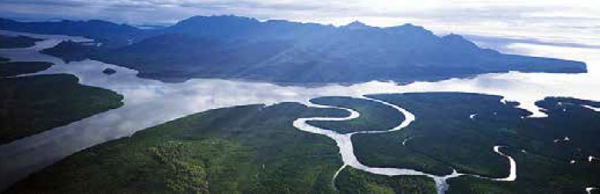
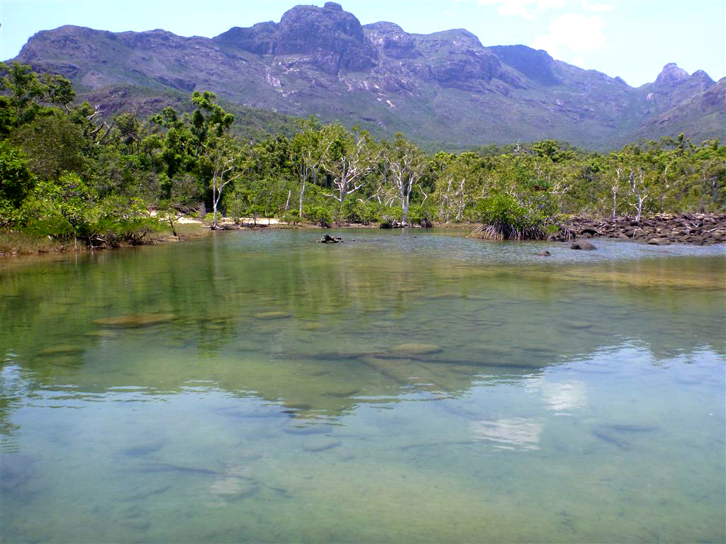
MEDIA RELEASE        
  17 October 2018

Alliance to Save Hinchinbrook Inc.
Queensland Government wants built accommodation OUTSIDE resort lease – on self-reliant WILDERNESS walk!   
The last time we called HANDS OFF HINCHINBROOK! was in the 1990s – to protect Hinchinbrook Island from the depredations of white shoe brigader Keith Williams. Williams wanted track hardening of the Thorsborne Trail, rock walled harbours and other built infrastructure on Hinchinbrook Island - outside the resort lease.
Picture
Photo Besthike.com
Now it’s the government to whom we say HANDS OFF HINCHINBROOK! - to protect Hinchinbrook Island from government proposals for accommodation infrastructure and guided tours along a self-reliant wilderness walk, in a national park that is the jewel in the crown of the Great Barrier Reef World Heritage Area (GBRWHA).   See:
“Delivery and operation of eco-accommodation and tour guidance for Thorsborne Trail” - tender invitation 12 October 2018 (Queensland Department Innovation Tourism Industry Development and the Commonwealth Games).


Ms Moorhouse said: “The state government decision to introduce accommodation and guided tours on Hinchinbrook Island’s Thorsborne Trail undermines not only the exceptional world heritage evaluation of this wilderness island – but also the government’s credibility as a holder and manager of protected lands.”​ 

​“It is astounding that neither Tourism nor Environment portfolios seem to understand that Hinchinbrook Island was gazetted and dedicated as national park precisely to preserve its special natural values. The purpose of all national parks is conservation.”
Picture
Photo besthike.com
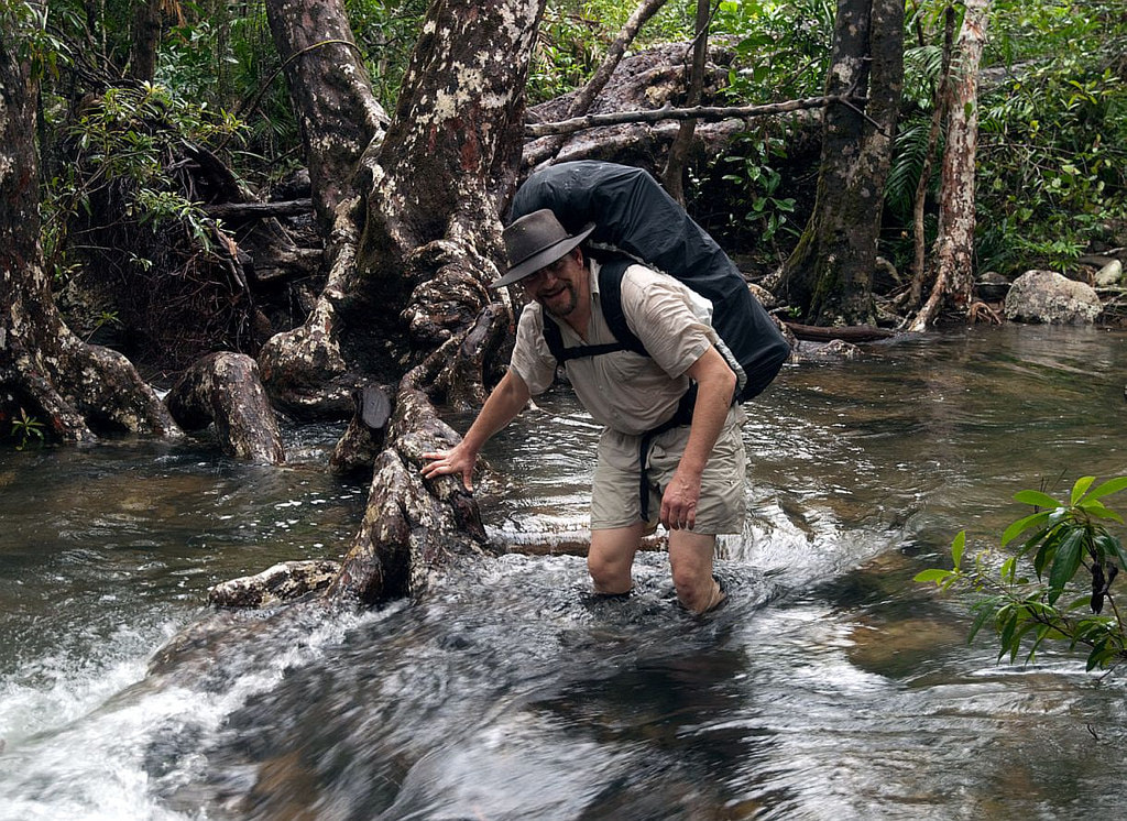
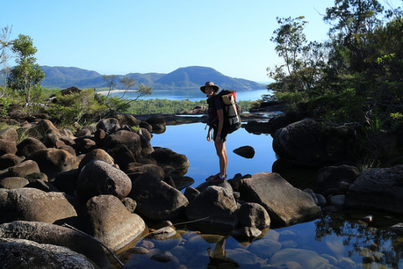
 "The purpose of all national parks is conservation"
                        
“These two portfolios denigrate the Trail as “rudimentary” (see below) – they don’t seem to understand that “self-reliant” and “wilderness” means: no buildings, no guides, no commerce.”
“And they have ignored the recently reviewed Hinchinbrook Island National Park Management Plan.”
The Thorsborne Trail is internationally renowned as a rare recreational experience; a 4-5 day remote area wilderness walk, available to those who can carry all they need for a nature immersion experience.
Small walking parties – singles, couples, families – can appreciate this special experience, out of sight and sound of other walkers.
The success of a wilderness trail is measured not by “how many” visitors but by whether or not natural processes remain undisturbed.
​
On 26 April 2018 the DES Minister’s Office advised ASH that we would be notified of matters affecting Hinchinbrook Island. ASH received no such notification.
​

FROM THE QUEENSLAND GOVERNMENT
Thorsborne Trail, Hinchinbrook Island National Park
The Thorsborne Trail is an existing rudimentary 32 kilometres class 5 trail along the eastern coast of Hinchinbrook Island off Cardwell, Queensland. The island is home to the world’s largest number of man-grove species and has significant environmental and natural attraction.
The public has access to the track and associated facilities, albeit with a limit of 40 people at a time. There is a well-recognised potential for an upgrade of the track and boardwalks as well as construction of accommodation pods to enable 3/4-day walks.
For more information on the existing trail, visit Department of Environment and Science website

Located on the largest island national park in Australia, the Thorsborne Trail features public campsites, toilets, picnic tables and water collection points. The Trail is 32km long, not graded or hardened and, as a Grade 5 trail in its most difficult sections, is considered challenging to hike. Most visitors hiking the entire Trail take between three and seven days to do so.
(FROM The Department of Tourism, Major Events, Small Business and the Commonwealth Games has transitioned to the Department of Innovation, Tourism Industry Development and the Commonwealth Games. We are continuing to update this website working with other Queensland Government departments.)

SEE ALSO HINCHINBROOK ISLAND NATIONAL PARK MANAGEMENT PLAN, 
The government's MEDIA RELEASE: and
The government's invitation for EXPRESSIONS OF INTEREST HERE and  HERE
Picture
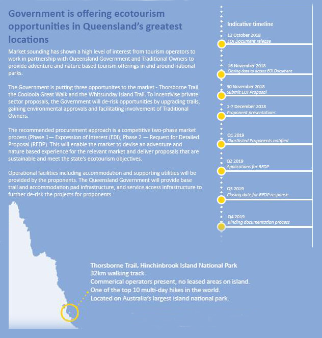
Download EOI PDF
CONTACT: Margaret Moorhouse  (Mob) 0427 724 052
 email: [email protected]
​www.hinchinbrook.com
0 Comments

GBRMPA  muliplies GBR 'Collapse'  -  at Mission Beach

24/7/2018

0 Comments

 
​In response to The Age (20 July 2018) 'Australian governments concede GBR headed for 'collapse':

This official recognition of the impending death of the Great Barrier Reef coral ecosystem hides an unpublicised and deadly multiplier.

The 
Great Barrier Reef Marine Park Authority (GBRMPA) and its political masters, the Commonwealth and Queensland Governments, are actively facilitating maritime constructions along the coast of Great Barrier Reef World Heritage Area (GBRWHA), in defiance of UNESCO’s clear warnings that the GBRMPA should stop ignoring cumulative, combined and consequential impacts – “death by a thousand cuts” (UNESCO Mission Report 2012).
Picture
.Case study: Clump Point Mission Beach – a new island marina development (a 30-year aspiration of Senator Bob Katter and a handful of development speculators) in and affecting the Great Barrier Reef Marine Park, the Great Barrier Reef World Heritage Area, and the Queensland Great Barrier Reef Coastal Marine Park.

This development has now been approved (and partial funding provided) by the Queensland and Commonwealth governments. The project began as a Queensland “major project of state significance” but was re-invented as “code-assessable” for automated intra-departmental tick-and- flick approval so that no public consultation was “required”.   
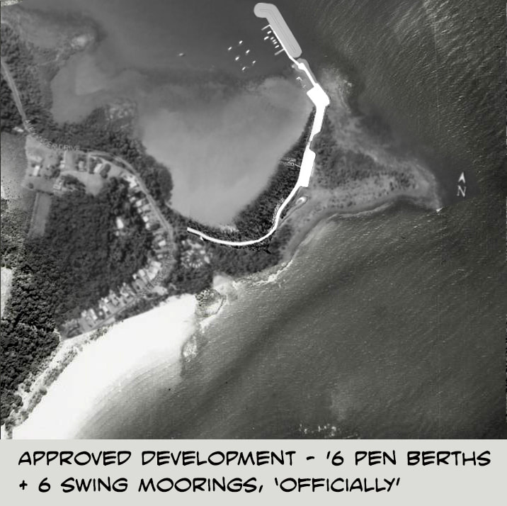
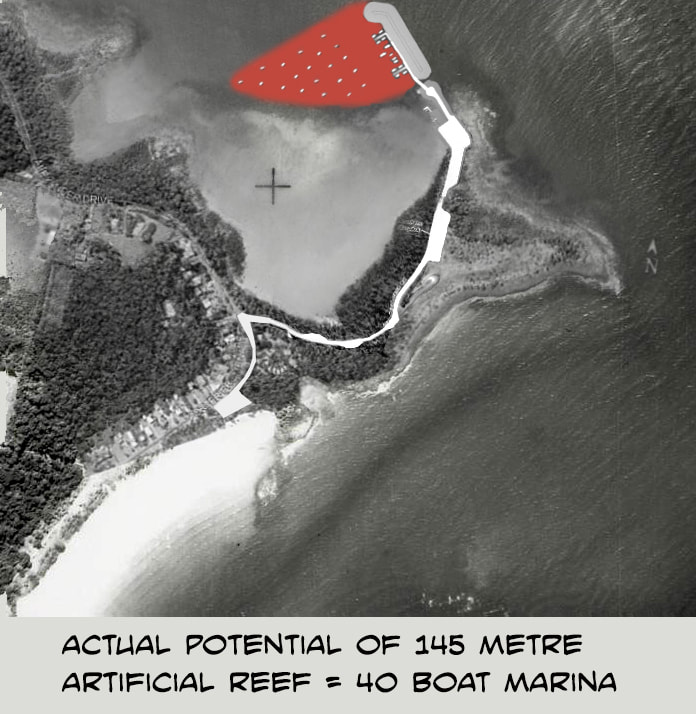
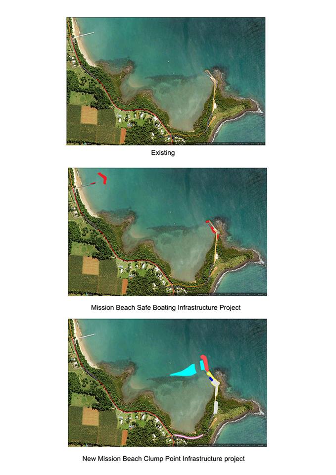
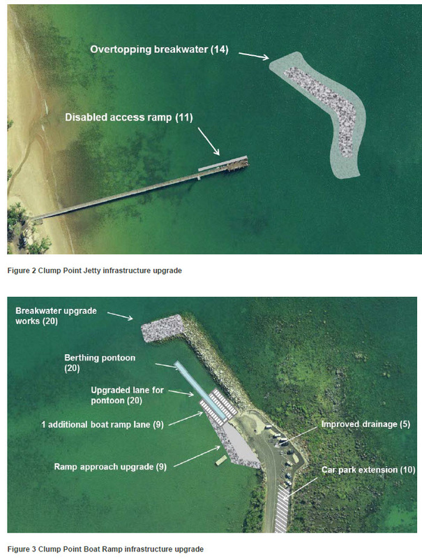
Funding: In the Application Public Information Package the Queensland government made clear that it had not committed funds for the whole project – an obvious invitation to the developers (in line with Queensland government policy) who have been seeking an island marina at Mission Beach for 33 years.

​

"This official recognition of the impending death of the Great Barrier Reef coral ecosystem hides an unpublicised and deadly multiplier."
​​                                           
Picture
Picture
​The GBRMPA approval was more tricky: how to get past the Great Barrier Reef Marine Park Act and Regulations. This was explained to Bob Katter and Queensland officials by the GBRMPA Assessment Officer (audio record 2016) – the same officer who ultimately approved the Application.

The GBRMPA could not, however, avoid “public notification”. Hiding behind their minimalist and outmoded regulations (email correspondence GBRMPA-ASH), they chose to bury their unpredictably timed and appealable Approval notification deep in their website, failing to notify either submitters or the government-appointed, local, Project Reference Group members. This meant that anyone seeking a Reconsideration missed out or found out with little time to make the formal Request.
​
This is how the GBRMPA “protects” the GBRWHA from harm.

​Similarly, the Queensland government failed to notify the public or the Project Reference Group, when referring the development proposal to the Commonwealth Environment Department as required under the EPBC Ac). The Department noted “no submissions” and happily approved it; perhaps unaware the public had not been notified., Nor did they know that the contents of the Application were misleading – an obvious reason for the Queensland government to keep the Referral from the knowledgeable non-government members of the Project Reference Group. By the time someone in the public found out, it was legally too late to make the appropriate submission.

​"Coastal fringing coral reefs of the GBRWHA are succumbing not to climate change but to coastal development"
​
Picture
The project also avoided the Commonwealth Environment Protection (Sea Dumping) Act, purportedly because the environmental impacts could be ignored legally, depending on what descriptor was given to the rock structure (in fact a fully constructed artificial island is proposed, but described differently).
​
Meanwhile, on the coastal verge of the GBRWHA: it was easy to blame the farmers for coastal pollution reaching the outer reefs, and propose they abide by voluntary measures, after Queensland’s Bligh government abolished the only legislation that had used statutory zoning to  protect the GBRWHA coast from “adverse impacts” (2012); followed by the Newman government abolishing riverine protection (2013).
​Local councils followed with glee. Under Queensland government policy of not interfering in local council business, the Cassowary Coast Regional Council (CCRC) (covering the narrow coastal strip between the Great Barrier Reef World Heritage Area and the Wet Tropics of Queensland 
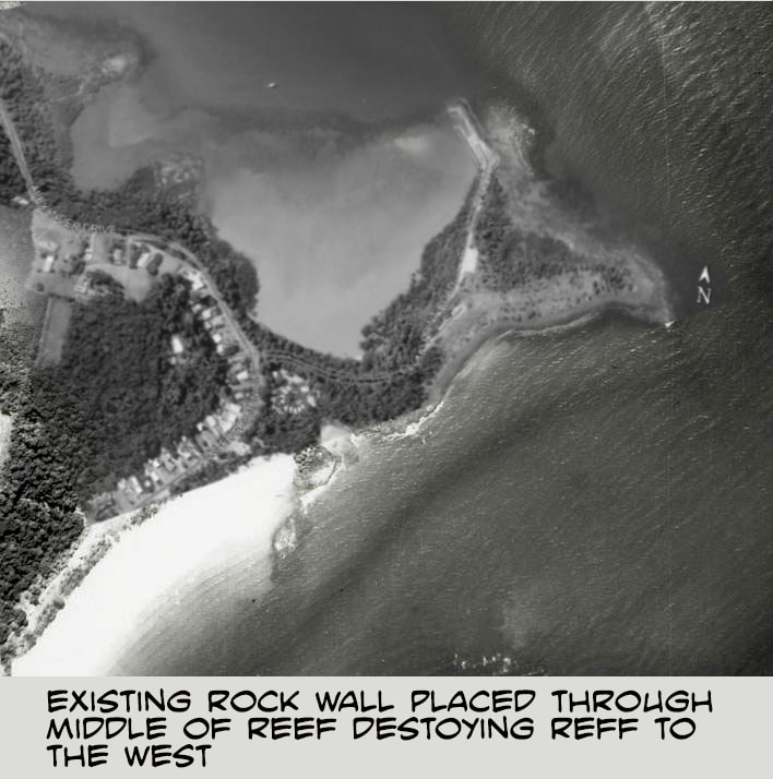
World Heritage Area) is formally subsidising new development contrary to state planning and local zoning New developers are offered fee-free application, two years rate-free, and a waiver of the standard requirement to contribute to the public infrastructure costs their development will cause (CCRC website). Pity the 10,000 or so mum-and-dad ratepayers. And pity the conservation zones now approved for development.
In sum: under cover of the destruction of the greatest reefal coral ecosystem on earth by climate change inaction, all levels of government are compromising what’s left of the GBRWHA - in the name of business and votes, unnoticed in far-away Victoria. I know Victorians love the idea of the “the Reef”; but few know that it is doomed, even without climate change, by government development decisions. Not just for Adani and ports and mines, but for dredging, reclamation, seadumping and bed-levelling inside the GBRWHA; by multiple coastal development approvals that are inaccessible to public consultation; by decisions made by the Queensland Government, the GBRMPA and the Commonwealth Environment Minister.

Coastal fringing coral reefs of the GBRWHA are succumbing not to climate change but to coastal development, whether by direct destruction or by pollution (eg Magnetic Island, Cleveland Bay, Clump Point Mission Beach).
One further act of propaganda: while the Commonwealth cannot change the boundaries of the GBR World Heritage Area (low water mark along the mainland coast), they repeatedly change the boundaries of the GBR Marine Park (also low water mark along the mainland coast but with deviations) specifically to exclude new areas of dredging, seadumping and reclamation; or dismiss them from consideration as “de minimis” - a legal principle directly in conflict with Australia’s obligations under world heritage listing (Conservation, Rehabilitation, Presentation – “to the utmost”) and the direct statements of UNESCO that the GBRMPA must take into account cumulative, combined and consequential impacts precisely to avoid “death by a thousand cuts” (UNESCO Mission Report 2012). Today, August 2018, GBRMPA has not even drafted such a policy.
Picture
Australians are to be applauded for their in-principle support for the life of the GBRWHA - the interdependent life of reef and coastal corals, seagrass and benthic communities, marine mammals and turtles and a multitude of fish species. Now Australians can ask the governments to stop hastening its demise through approvals of additional and preventable coastal development impacts
 
 Margaret J Moorhouse
Alliance to Save Hinchinbrook Inc
PO Box 2457
Townsville Q 4810
[email protected]
0427 724 052
Picture
0 Comments

Up to date info on Clump Point

3/12/2017

0 Comments


Save Clump Point website

Save Clump Point  - the facts 

Save Clump Point  - facebook page 

Picture
0 Comments

Aurecon's Clump Point solution

21/12/2013

0 Comments

 
Picture
On 29th November 2013 at the Mission Beach Resort, Aurecon gave a presentation to invited stakeholders outlining the process to decide the designs for the 'Safe boating infrastructure Project' at Clump Point. 

Of the 20 options considered in the  Multi Criteria Analysis (MCA)  a rock wall island breakwater at the head of the jetty and an upgrade of the existing Clump Point boat ramp (left) were  promoted as the best solutions to their brief in the Invitation to Offer (ITO)

The following is the considered response to Aurecon's recommendations by the Cassowary Coast Alliance (CCA)

CCA supports the decision to provide facilities for berthing only, with no mooring of marine vessels, and choosing the low key option to provide safer boating at the boat ramp.

CCA does not support the addition of a rock wall breakwater in an attempt to provide calm water at the jetty.


                                                                                      Read more
0 Comments

The future of  Port Hinchinbrook

4/12/2013

0 Comments

 
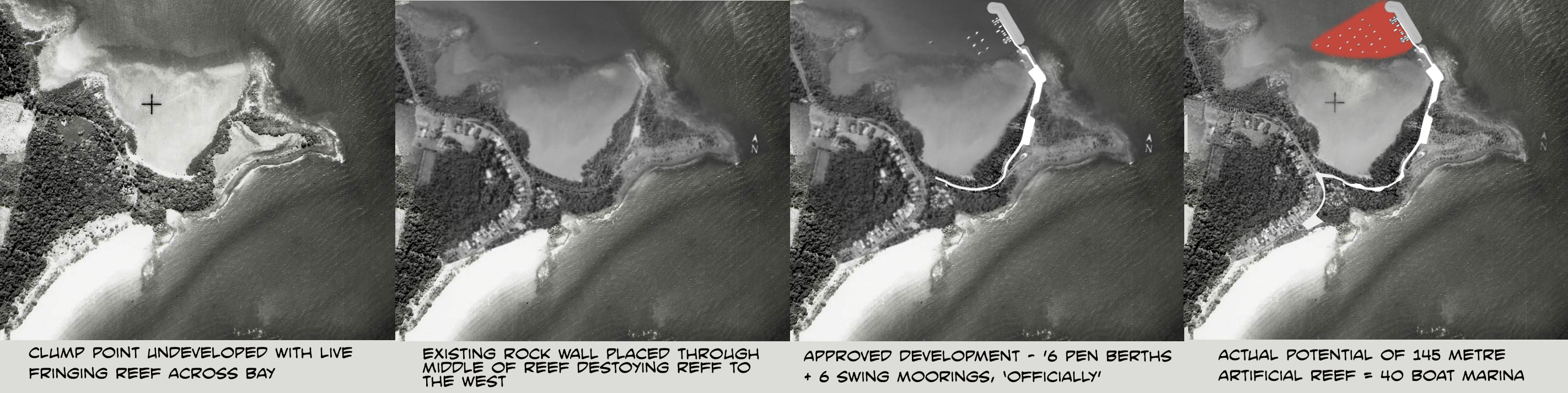
By Margaret Moorhouse, Alliance to Save Hinchinbrook
Picture
Hinchinbrook Island, Photo: Steven Nowakowski.
Williams Corporation and Port Hinchinbrook Services are both in liquidation. During its interaction with the proponents of the intended Deed of Company Arrangement (DoCA), the Alliance to Save Hinchinbroook Inc (ASH) corresponded
with the Administrators just as they became the Liquidators.
Suffice to say that we do not hold the same confidence in liquidators as does the Mayor of the Cassowary Coast Regional Council (Innisfail Advocate 28 Sep 2013).

Read More
0 Comments

News from Coquette Point

19/10/2013

0 Comments

 
Mission Beach Cassowaries
Beach Stone Curlew - Photo Yvonne Cunningham
Hello from Coquette Point,
Tonight, wild fires rage throughout New South Wales, the fires have already burnt out over two hundred homes. So far only one person has died and that from a heart attack defending his home. However, fire fighters from all over Australia have rallied to help and these men and  women put their lives on the line when they tackle the fire-front from the ground. They are super-humans.

Meanwhile the drought throughout central and western Queensland only deepens while south-east Queensland on Friday was  battered with severe storms and hail. Winds of over 120km per hour were  recorded.

The northern hemisphere's monsoon continues to be extremely active and tonight Super Typhoon 'Francisco' category 4 is heading for Kyoto Japan. There are 10 nuclear facilities in the typhoon's danger zone.

Is our beautiful blue  planet trying to tell us something?
Read more
0 Comments

Newman Government: the new National Parks cash converters

19/10/2013

3 Comments

 
Picture
Little Ramsay Bay - Hinchinbrook Island. Photo Mission Beach Charters
Media release - 16th October 2013
To the residents of the Cassowary Coast Region,  tourists and all those who value Queensland's biodiversity: join us in opposing the Newman Government's predation of National Parks and the rush to convert priceless wildlife reserves into lifeless cash.

Queensland has a miniscule percentage (4.8%) of land historically protected   as national park, less than any other state. Nevertheless, the State government intends to sacrifice even this last tiny bastion of nature protection, our state's last public good, on the altar of profit-taking.

Read More
3 Comments

Different Drum from Mission Beach

10/9/2013

0 Comments

 
Picture

Leunig for Prime Minister!

While radical decisions are being made that will have a long term detrimental affect on our natural environment, the life it supports continues to find ways to survive - or not.
 
The opportunistic feeding habits of the cassowary has enabled it to adapt, to a certain extent, to the encroachment of development. It also  brings the known threats to its survival.  

Read More
0 Comments

News from Coquette Point

9/9/2013

0 Comments

 
Picture
Previous signs describing the Coquette Point Foreshore and Wetlands as part of the Wet Tropics World Heritage were vandalised.  I hope all people visiting the foreshore area now will learn how special this place is and realise the intrinsic value of 'this home for birds'.

Three generations of the Epong family belonging to the Mandaburra clan, right to left, Henry, Nellie, James and in the front Michael-John were delighted to inspect the new Coquette Point signs, before going for a walk on the foreshore to see which migratory shore birds had arrived.

The wind was blowing very strongly and a sandstorm occurred as we walked around the low side of the rookery.

 In the lee of the dune three pelicans and a darter were sheltering from the  wind.
Read More
0 Comments
<<Previous
    Picture
    The Cassowary Coast Alliance (CCA) is a collaborative hub for entities and individuals who
    are actively seeking good quality and long term public interest outcomes for the world
    heritage listed Cassowary Coast in Far North Queensland.
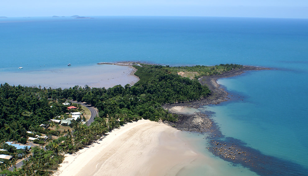
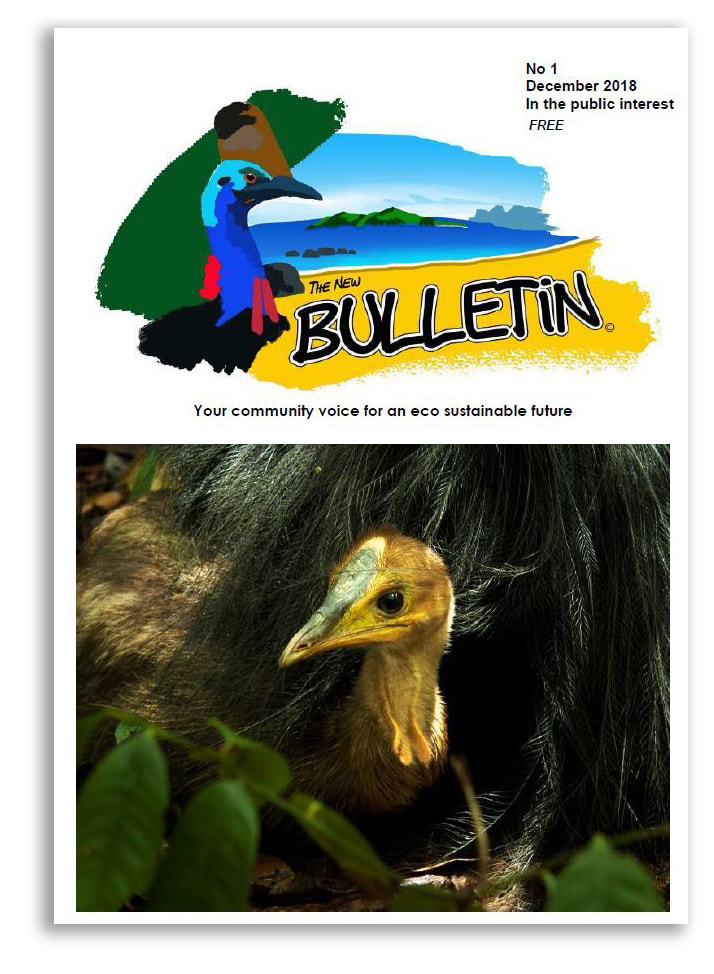
    Picture

    Picture
    Picture
    Picture
    Picture
    Picture

    December 2018
    October 2018
    July 2018
    December 2017
    December 2013
    October 2013
    September 2013
    August 2013
    July 2013
    June 2013
    April 2013
    March 2013
    February 2013
    January 2013
    December 2012
    November 2012
    August 2012
    July 2012
    June 2012
    May 2012


    All
    Ash
    Birds
    Cassowaries
    Coastal Planning
    Coquette Point
    Hinchinbrook
    Mission Beach
    Monsoon
    Take Action
    Threats
    Wildwatch
    W P S Q

    RSS Feed